Coaticook region - looks a lot like Vermont!

Quebec cows?
I have just returned from a place that is geographically identical to beautiful Vermont, except it is here in Quebec.
Where is this mysterious place?
In the far-eastern Eastern Townships, south and east of Sherbrooke is a place where you can have an incredible Est-Capade. Yes, it's the Reseau cyclable l'Est-Capade de la MRC Coaticook.
Before I go on, you should know that this network is a mix of asphalt and dirt roads. Some of the dirt roads are marked expert, and this means they are steep. Since East Hereford has a mountain bike trails, you should consider the roads marked expert as part of that network too. It also means read the map carefully and "Pay attention" because roads marked expert have steep hills and might have to be walked (up AND down) if you are on a road bike. However, the ride I did was road-bikeable, with the exception of a 1 km section in the mountain pass.

The village Catholic church, every town's got one
Let's get on with the ride!
I parked the car in Ste-Hermenengilde and rode to St-Malo and East-Hereford, and the natural beauty, rural scenery, and great roads reminded me of Vermont, except I didn't have to cross the border.
My Friend M. had said that this was her favorite spot for cycling. I had visited here a couple of decades ago, and thought it was time for another visit. It was worth it. I have found yet another beautiful spot for cycling here in Quebec.
M's directions were a bit vague, but I mapped out what looked like a good a route using Google Maps. Unfortunately this excellent trip planning device doesn't identify dirt roads. And especially, dirt roads through mountain passes!
Nothing is better than cycling through a mountain pass. It's even better when the pass is paved with asphalt! But this route was not paved, but that didn't stop me, I just had to walk one steep hill, and the rest was perfectly rideable. And the peacefulness was without comparison!
I was thinking of a ride in northeast Vermont near the border, but when I spoke to M. I decided to stay on this side of the border and explore. This was one of my more-adventurous explorations, I can tell you!
The ride started in Ste-Hermemegilde, south of Coaticook. I parked at the church and headed north on nice roads to the 9 Rang road, which took me east.
The terrain was hilly, but the road quality was good.

Todays theme: good roads, good hills, and good scenic splendour
I turned off the paved road onto a well-maintained dirt road, and was fine for cycling, and even had designated bike-road signs.

Dirt road maintained for cycling
The road maintained it's excellent quality for a while, but eventually it became single-lane and not quite as well-maintained. I did not see another soul for several miles, and I wondered, will I be eaten by wolves? Or will it be the bears that get me? Or, maybe a northern lynx? The place was that wild.
I came upon one steep hill that I had to walk, but the rest was generally rideable, even the downhills, as long as I was paying attention and staying on the solid part of the road. I had been thinking I should swap my fat 700x25 tires for 700x21, but today I was reminded why I ride the big rubber. The back one just fits inside the frame, a situation not too often found on today's anorexic race bikes.

The mountain pass road is actually marked for bicycles...
Happily I eventually came upon a sign saying I was in St-Malo municipality, and also saw a address with Chemin Eaton written on it, meaning I was on the good road, and not lost, and maybe civilization would be around the next corner, or hopefully the one after that?

A bike rest stop, sign says I'm on the good road, and what's in the tree?
Yes, did come out the other side without any carnivorous animals trailing me, hoping for a meal of tasty cyclist.
Once I was back in the populated part of the world and there was pavement under my wheels I rolled along a great road west into St-Malo, and then I would ride south to East Hereford and the US border.

St-Malo's most excellent attraction - La Tour - Altitude 590m!
St-Malo's attraction is a lookout tower they built on the highest point of land in the village, which is itself on a hill. I had my usual dep energy refill: a chocolate milk and some Reeses peanut butter cups and refilled my gatorcrapade.

St-Malo from lookout tower, the mountain pass on hazy horizon
From St-Malo it was dowhill to St-Venant de Paquette, home of a poetry trail.

Mid-ride diversion in Paquette

South of here I followed the Rt 253 as far as the US Border along the Hall river, the other side of the river is New Hampshire. The Hall river valley is both flat, and very scenic. It's a 6 km each way detour from the ride's turning-point in East Hereford.
Here is an interesting history item on how the US border came to be along this river. It's the story of the "Indian Stream Republic" and guess what, the land became part of the US. Quelle surprise.
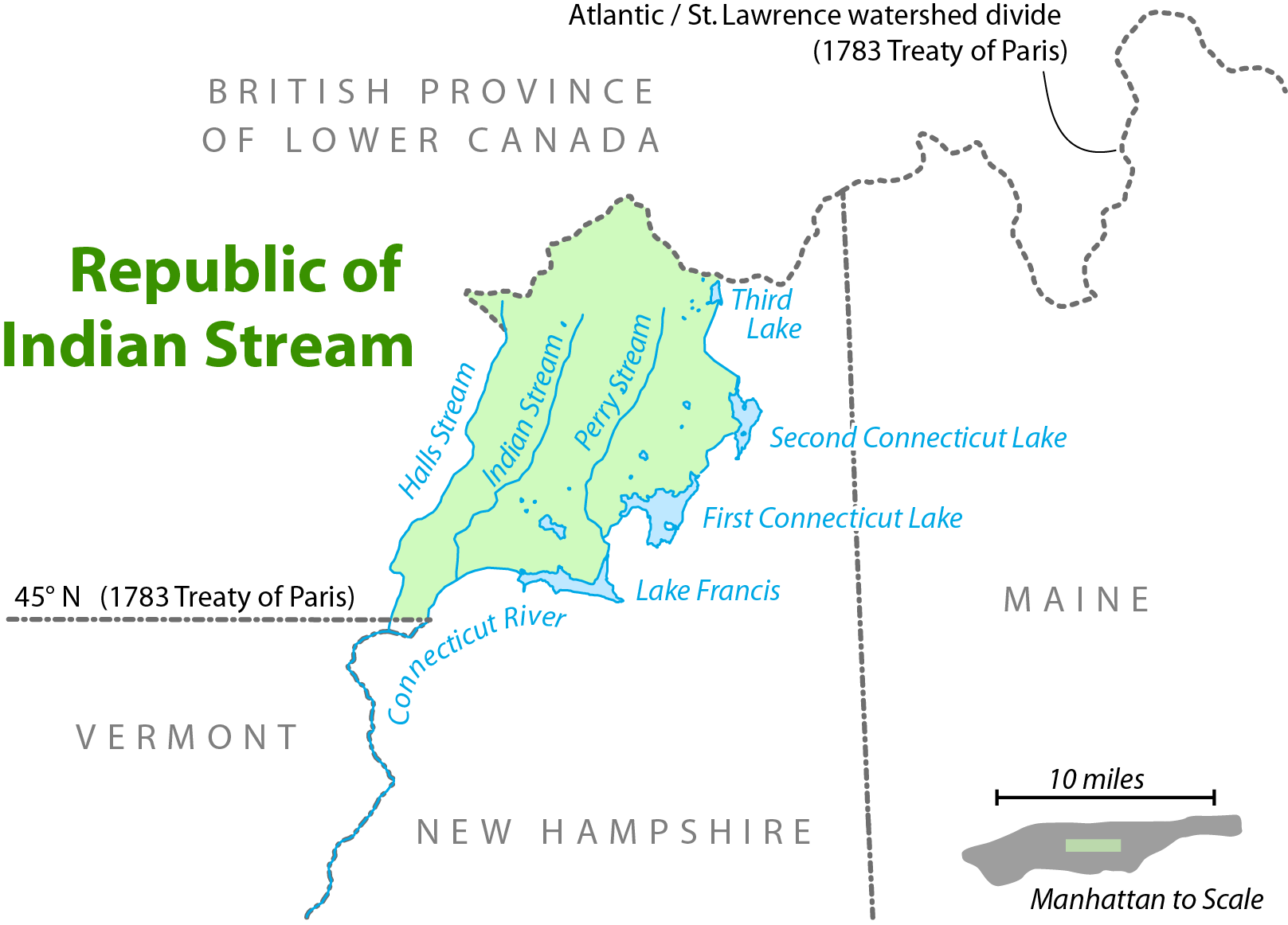
The disputed land in the Indian Stream Republic

East Hereford Customs, note the thunderclouds in background, uh-oh.
Turning around at the Customs I rode back north (option is to do a loop through the US and come back north on Rt 141) , and I notice interesting, and ominous, clouds.
Uh-oh.
The weather arrived in a few minutes and it was what the weatherman describes as "Risk of Severe Thunderstorms."
Uh-oh.
So I camp out in someone's front yard, and enjoy the show, Constant lightning and thunder for the next 45 minutes.

Looks like rain, feels like rain, Sounds like thunder.
Eventually it let up and I continued home, still raining and occasional lightning. I was more than a little concerned to be riding on top of 20 pounds of metal! But the way home was where I was headed, and I was what you'd call a motivated rider!
Eventually I arrived back closer and closer to my starting point of St-Hermenegilde. Amidst the rain, black clouds, and lightning and thunder, in the distance the sky parted right above my destination, I took it as a sign that I would make it back ok, and that everything would be fine.

St-Hermenegilde in the distance, black skies with clouds parting and sun shining down looking like a sign from god. I was saved!
I got back to the car, and as I opened the door, just in time for the last piece of the weather menu to arrive.
Severe hail!
Am I glad I got to the car 30 seconds before that? Oh yeah, timing is everything, and this time my timing worked out to the second! Maybe that's too close?
Weather can be so contrary sometime.
But the hail stopped, I changed into dry clothes, and came home safe and sound.
What a day!
************
Links:
This region has another name: Les Trois Villages (click here to visit)
posted by Cycle Fun Montreal @ 9:37 AM
2 comments
![]()
![]()


2 Comments:
Do you know if L'EstCapade is still maintained or do you know where to get more info about it? So far, I've only found a couple references online and this map: http://www.pistescyclables.ca/Cantons/Cantons.htm which has the route but does not have the details.
Thanks!
Grant
all the trails on that map exist. For better maps google "tourism eastern townships" and look for L'Estriade. http://www.easterntownships.org/practical/25/circuits-velo?activity=34
Post a Comment
<< Home