Saturday, August 25, 2007

"Northest" Northern Lanaudiere Ride

St-Emilie-de-L'Energie to St-Michel-des-Saints

Northern Lanaudiere (eastern Laurentians) - civilization's northern boundary

Plan A: St-Emilie de l'Energie to St-Michel-des-Saints (100km roundtrip)
Optimistic plan B: Continie to entrance for Parc Tremblant (50 km more)

Lanaudiere.

Northern Lanaudiere.

Go North to the most North in Lanaudiere: St-Michel des Saints.

In a previous episode, I rode as far north as St-Emilie de L'Energie.

Tomorrow, head north - to the end of the road!

Then turn around and ride downhill, because this road will go downhill, and downhill, and downhill.

No ride is complete without a longer option, so if things are going good, I will continue to the St-Michel-des-Saints entrance to Parc Tremblant provincial park.

The distance of the first stage is 50 km, and the option is 25 km, so the entire ride will be 100 or 150 km. This is an out and back ride: I will be returning on the same roads as I rode north.

Stay tuned.

UPDATE: I had a great 120 km ride. St-Emilie de l'Energie to St-Zenon to St-Michel-des-Saints, and part of the way to the Parc entrance. I turned around when my tire popped off the rim. Ooops. Bang!


The ride along the Rt 131 from St-Emilie de l'Energie to St-Zenon to St-Michel-des-Saints is excellent, with full paved shoulder for 100% of the 50 km distance between these three towns.

St-Zenon - at 500 m it's "La Summit de Lanaudiere"


Rest stop "with-a-view" in St-Zenon


A lighthouse, in the northern laurentians?


Rt 131 often followed rivers and lakes


The first descent of the route north - a good one!

Sunday, August 19, 2007

Beautiful St-Anicet-Dundee Haut St-Laurent ride

How about some Sunday flats to go with Saturday's Sutton hill-riding extravaganza?

Sounds like a plan.

I dug up my "Le Suroit tourist guide 2006-2007" and went to the bike map section. Of the six road-rides I choose the circuit around St-Anicet called "The border cycling network." Not a very spicy name, I gotta say. But the ride sounded good, and it is the farthest west corner of Quebec south of the St-Laurence river.

The ride follows the st-Laurence river bank, then goes inland and ride rolling terrain formed when the last ice-age ended, 15,000 years ago. There are great views of the most northern of the Adirondack mountains. Did you know that these mountains are an extension of the Canadian Shield?


At the farthest-west point of the ride is the end/start of the Rt 132, at the Dundee customs. Riding back east was scenic with great views of foothills and many quiet country roads. A pure delight.

There were many sights along the way, not least was the very different-looking church in St-Anicet. There was also a functional Iroqois fort!

Conclusion, a scenic ride with a modest 75 km distance. A good recovery ride, the start is located about 100 km and 90 minutes from Montreal via Valleyfield. Recommended.

Where is St-Anicet?


Located in south-western Quebec between the St-Laurence river and the Adirondack mountains of New York state, USA.

Here is the ride map from the Le Suroit Tourist Guide:


A great ride, it exceeded my expectations in every way!

Sutton Loop - Southern Quebec's most beautiful ride


Owls Head around sunset

I just got back from a loop around the Sutton Mountains in Quebec's Eastern Townships (Cantons de l'est), and this is the most scenic ride I've done in a while. And I've done a lot!

I parked at the rest stop on Rt 243 beside South Bolton, at the start of the Bolton Pass.

The ride details are:

  • Bolton Pass to Knowlton (Lac Brome) (very scenic)
  • Knowlton to Sutton vis Chemin Echo (very scenic)
  • Sutton to Glen Sutton via Chemin Scenic & Chemin de la vallée Mississquoi(very scenic)
  • Glen Sutton to Mansonville in mississiquoi river valley(very scenic)
  • 6 km out-and-back Covered Bridge (Pont de la Frontiere)(very scenic)
  • Mansonville to Owls head vis chemin Vale Perkins(very scenic)
  • Detour 2 km out-and-back to lake Memphremagog dock and beach(very scenic)
  • North along Chenmin de Lac with views of Orford(very scenic)
  • Back to car via Bolton Centre and South Bolton

Frankly, a bike ride doesn't get better than this.


Covered bridge near Mansonville

The ride length was around 100-110 km. I think it would be around 75-80 if you went directly north from Mansonville to South Bolton on the 243(?).

If you wanted a really short and flat ride with really maximum scenery, I'd suggest riding from Mansonville to the US border on Chemin Missisiquoi. It follows the river valley, directions are completely simple, and the scenery: about as good as it gets! And don't forget to do the short side trip to the Mansonville covered bridge ("pont de la frontiere") because here is the best scenic vista in southern Quebec.

The Route:

Blue dots: the route
Red Dots: the two short side trips
green X - starting point/car parking at "halte"

Saturday, August 18, 2007

West of Montreal flatland ride

West of Montreal in the far reaches of the Monteregie is the little triangle of land btween the Ottawa and St-Laurence rivers and the Ontario border.

This is an attractive area for cycling. There is the excellent Canal Soulange bike path (with the Parc des Ancres anchor park with a Soulanges Canal museum at Point aux Cascades), the bikes-and-pedestrians ferry at Les Cedres across the St-Laurence to St-Timothée, a ride through or around valleyfield (maybe by the Beauharnois canal bike path), and tons of quiet and flat roads between the St Laurence and the Ottawa rivers.

My ride took in all these things, and since it was a flat land ride, there were no exciting descents to coast and recover). In other words, nonstop pedalling, which taught my calf muscles that flatland is about endurance and, well, endurance!

I rode these west-quebec flats through st-Polycarpe and up to St-Justine de Newton, and almost as far north as Rigaud.

It was a fine summer day, sunny and warm, and a great ride for seeing some of non-urban Quebec and not too far from Montreal.

Beating the rain - against the odds

I arrived at Ste-Jovite in a pouring rain storm on Friday afternoon. With my bike, with plans for a ride.

Did I give up?

No!

I figured that the storm was a very localized storm cell, and it would pass. But I hate waiting, so I drove what was to be the circuit (as sourced in the Velomag Randonnée des Reves guide book).
When I arrived at the turn to Val des Lacs, I noticed that 1) that the rain had gone away, and 2) that I was at the west end of the amazing chemin Nordet (aka chemin des cyclistes) between St-Donat and Lac Superieur.

Perhaps, maybe, if I assumed an attutude of extreme weather-positivity, I would have an hour or two ride on this amazing, newly-constructed road without any rain. THere could be rain to the east, west, north, and south, but the rainwould stay away from this road and specifically, the section of road that I was riding on.

That was the dream.

I got ready, locked the car and hopped on the bike. The first thing I notices was the temperature had dropped about 15 degrees and that it was actually cold. Well, that's better than rain.

I climbed hills, climbed some more hills, and then some more and was finally at the top of the big west-end climb of the ride. I wouldn't be able to go al the way to St-Donat, but from here I figured I could go a bit firther, perhaps to the river in the middle of this isolated plateau. This sounded good so I rode east, which from this point was downhill, hitting 75 km/h without really trying.

I could see rain clouds to the east, west, north and south, but non overhead. THe plan was working. I got to the bridge over the river and I could see major clouds to the east, so I u-turned here after 49 minutes of riding, and headed back. Black clouds were overhead, but the most I got was tiny amounts of light cloud spitting.

After several good climbs I hit the top, the famous lunch ledge with it's rock bench on top, but didn't stop. With ever-blacker clouds overhead I came down the west other side with lots of motivation, hitting about 72 km/h on this perfect road. I reached the car, parked at the turn to Val des Lacs (chemin quenouilles) without rain, but with a good 90 minute ride accomplished.

Mission Accomplished!

I had salvaged a good ride from the late afternoon weather gods.

Interestingly, I had spend the earlier part of the day on a test flight of the CRJ900 Nextgen aircraft, being self-loading ballast for a fuel-consumption measurement under passenger flight conditions. We flew north from Mirabel straight up the laurentians and flew laps of a circuit between Rouyn-Noranda to Roverval (saguenay) for about 4 hours.

During this time I watched the cloud cover build and build and the clouds get steadily more rain-filled. I knew there would be afternoon storms, and as I reached Ste-Jovite they let loose. So I was extremely happy to get this ride in with these conditions.

Friday, August 10, 2007

Cycling the Chateauguay Valley

Please click here to see my Chateauguay Valley bike ride posts.

(If you clicked and you still see this post, just scroll down the page to see the other posts)

The region around the Chateauguay River and Covey Hill is one of the nicest places for bike rides and tours in Quebec. And it is conveniently close to Montreal.

The downside: the ongoing construction on the Mercier bridge. I suggest these two alternatives. Take Autoroute 20 to (Salaberry de) Valleyfield and Rt 201 to Ormstown. Or, Take Champlain bridge and Autoroute 30 to Chateauguay, and Rt 138 to Ormstown.

Please take special care if you are following the Suroit road cycling map. This map suggests taking Rt 201 from Ormstown to St-Antoine-Abbé. This section of road is dangerous. It is very busy, has no paved shoulder, and the road edge is in poor condition. Take either north-south road to the east (i.e. via St-Pierre) or west (Rockburn to Dewittville) and you will be on magnificent and quiet country roads, the kinds of roads that you came here to find. I cannot understand how the mapmakers selected Rt 201 for cycling. Well, I suspect they never visited the area when they made the map. Clue: Rt 201!!!

Aside from this little problem, the suroit bike maps are another excellent way to discover the country roads of the valley.

Please click here for my Chateauguay Valley bike rides. These include:
  • Cycling Destination - Ormstown/Chateauguay Valley
  • My favorite Chateauguay Valley ride
  • Giant Covey Hill-Chateauguay valley ride
  • 100 Km Chateauguay Valley ride
  • Southwest Quebec - Le Suroit 2007 cycling maps
  • Scenic Ormstown to Powerscourt, Quebec Ride

These are some of my most popular posts, and you can see them all, just by clicking here.

Ride Safe!

Villages and other landmarks include: Ormstown, Howick, Huntingdon, Rockburn, Dewitville, Allan's Corners, The Rock, Franklin, St-Antoine-abbe, Powerscourt, Athelstan, Herdman, Brysonville, Tullochgorum, St-Pierre, Ste-Martine, Havelock, Covey hill, Hemmingford, Aubrey, Riverfield, Georgetown, Ridge road, first concession, Trout River, Malone, Chateaugay, Haut st-laurent, Chicken Valley Ranch, CVR, Ormstown beach, battle of the chateauguay, Valleyfield, seaway, canal, the fair, apples, apple orchards, and lots and lots of cows. Moo!

Route Verte Grand Opening

It's the grand opening of Quebec's amazing kilometre Route Verte bike path network.

It is a 4300 Km long collection of intermunicipal and regional bike paths, linking towns, cities and villages (which have their own paths and networks) all across Quebec.

In case you don't know it, Quebec is a very, very big province. How big? Total area is 1,542,056 sq. km. (595,391 SQ MI) By comparison, Alaska is 626,425 sq miles, and Texas is 261,797 sq miles.

Want to read more? I pass you to the real media:

letter to a friend

Subject: Ste-Herménégilde

Hi M.

While the memory (I think I might mean mental scars) is still fresh I need to ask you, when you visited St-Herménégilde, did you take a dirt road, through a mountain pass where the road kind of dries up into a mountain bike trail?

Because I did and I did because on google maps it looked like any other road, and on the ground it was a dirt road, but it was well maintained (at the start anyway) and the road was even marked as a bike road. I later learned that they have a big mountain biking thing going on at East Hereford and some dirt roads are rugged and adventurous (= steep!) enough to ride as mountain-bike rides.


It was still a road, and I was still road biking!

A good mountain bike ride, except I was on my road racing bike. Happily I don't use really skinny tires, my frame permits 700x25 tires (which just fit in the rear triangle area) so non-rugged off road is generally rideable.

Anyway this dirt road became one lane, and then became quite washed out, even though it was mostly rideable if one has a high level of adventurousness, since it added a lot of adventure (and the inevitable fear of "what if this isn't the right road?") , and of course the risk of being eaten by bears.

I thought I could hear them tracking me in the woods along the trail, I mean road, but I could be paranoid, it might have just been wolves, or packs of wild dogs. At least I know it wasn't lynx, which wait in the tree and jump on bike riders as they ride past (not unlike the anaconda... maybe my imagination is a bit too vivid...).

Happily, I eventually got out of these woods and noticed the sign at that end of the road identifying it as a cul-de-sac! I didn't have too much real difficulty besides the uncertainty and dealing with the practical reality of having to walk up the steepest hill (which even had a sign telling bikes watch out on the descent!), but the walking I don't mind, the forest is a nice place to be - and there were no cars!

Of course, I was genuinely happy to get back on asphalt-covered road and soon arrived next at St-Malo, which did have quite the good observation tower - thanks for this tip; it was a real highlight of the ride. The woman at the depanneur asked me if I was in the "Orage" that morning? "No," I said, "timing is everything" words that would return to bite me in the butt.

After St-Venant de Paquette and East Hereford I went down to the US border along the flat valley floor of the scenic Hall river valley road, when it started to rain a bit, which wasn't too bad, but when I turned around and headed north again, it began to rain a lot, and more importantly, lightning a LOT (like 10-30 blasts a minute), then I got worried, for a good reason.

I was at the exciting side of a thunderstorm cell, and this cell must have been pretty big because I had impressive lightning for the next hour. I was quite worried about me getting turned into toast (burnt toast), because my mode of transportation involved riding on top a big hunk of lightning-attracting metal. So I waited under a tree for an hour until I became convinced that the lightning was slowing down, and a local woman even offered to take me in out of the rain (actually I was under a pretty good tree) because I must still have resembled the proverbial drowned rat.

The rain slowed down a lot sooner than the lightning, but eventually the lightning tapered off (i.e. I optimistically imagined (believed... I believed!) It had moved further south) and I rode home the last 20 km to the car in Ste-Herménégilde in light rain and distant lightning. (I recently read that if you can hear thunder, you are in the lightning risk zone!)

After 20 km of riding in lighter and heavier rain, I got to the spot where I could see Ste-Herménégilde in the distance. Unusually, the black skies actually opened up and sun shone down above Ste-Herménégilde (and only above Ste-Herménégilde!!!!) in a kind of biblical heavens-parting – golden glow - here come the angels to take me home - moment. My blog (google "cycle fun Montreal") photo shows this detail well, it was kind of very encouraging, and I managed to get back to the car in one piece, and I sure wasn't dehydrated!

Natch, the fun wasn't over yet. Just as I got to the car (to the second) and opened the door, the HAIL arrived.

Yeah, the weather gods were pissed at me, that's the only conclusion I can reach. But my timing was ok: If I had waited another five minutes under the tree I would have been outside on the road during the hail storm, and probably would have impressive bruises from the hail all over my body. I was certainly glad and thankful to have avoided that!

One conclusion I have is if I had not dawdled (=stop a lot) on the ride I probably would have entirely beaten the rain and weather excitement. So on Sunday's sunny ride in Lanaudiere I didn't dawdle, and had a nice 24 km/h avg speed for a 96 km ride, and this with at least five 16% hills. Sunday's weather was a lot nicer too, I have to say. And on Sunday my avg speed moved from 23.9 to 24.0 in the very last kilometre of riding, which was nice of it! It had been a while since I focus on riding speed, rather than my usual taking it easy too much.

Conclusion: I now know what it means when the weather report says risk of severe thunderstorms.

Otherwise, it was a great ride, and I can't wait to discover what your actual ride route is supposed to be, because the ride imagined and mapped, and the ride I actually did, and the ride you did are all quite different.

Conclusion: a nice ride... for a sunny day!

d.

Re: Ste-Herménégilde

Hi D,

Always an adventure when you are out on your bike!!!!!!!!!!

When are you going to write in the ''real world'', like a book, perhaps a ''recueil de nouvelles''!!!!!

My Grand Tour experience was great. Three days of great scenery. Our average speed was exceptionally high. I think the masse of bikers creates a vortex that you get pulled along by because I've never rode so fast so easily. The last day was an epic 128km on the 172 from Jonquière to Sacré-Coeur. We got into about 40km of rain in the Parc du Sagnenay but spirits were high with good company. 128km is my new record for one day!

It is quite an organization moving a village on 2,400 bikers from one town/city to another! The food was exceptional with emphasis on ''les produits du terroir''. The best lunch was a wild rice salad with a piece of poached salmon and ''terrine de bison'' and a blueberry chantilly dessert!

I got up one morning at about 5 o'clock to go to the bathroom and took a picture of the village of tents with the sun coming up...pretty amazing!

2,000 bikers continued on yesterday in horrible rain and wind but today they will be riding the Charlevoix hills with the sun and, I suspect, wet shoes!!

I'll some it up to this: It is a great, but like Las Vegas, three days is enough!

Ride safe (bring a map!),

M.

Re: Ste-Herménégilde

Hi M.

It sounds like you had a good time in blueberryland.

128 km is a good distance for a day, on a road bike distance is easily conquered, and yes, a group does move quite a bit faster than solo (it's sort of the opposite of the workplace). And of course, if there's a tailwind....

When everything goes good, there's nothing better on this planet than a few hours of bike-induced happiness. And if it is fully supported riding, well, let the good times "roll!" (Seriously, can life get any better than this?)

For me the problem with rain isn't the riding in it, (that is "good" misery) it's putting on wet shoes the next day (ugh - bad misery!).

For the record, it's not always an adventure when I go for a ride, but it does make for better email. For real adventure, I go to Chinese restaurants and order Ma-Po tofu, which is the only food I ever ordered that is a totally, completely, different dish from restaurant to restaurant. (But always delicious).

Mmmm blueberries....

Cycling and Canoeing combo

Cycling and canoeing are a surprisingly complementary pair of "fresh air" activities.

You paddle down the river, and then lock the canoe, unlock the pre-parked bike, and cycle back to pick up the car.

Here is a link to a Le Soleil (Quebec city) article on combining canoeing and bikes.

Before I had read this article, I had already planned a family canoe day on the Chateauguay River, starting in Huntingdon, Quebec.

I now regret selling my canoe in the late 1990s. But I have plans the build a wooden sea kayak some year soon.

Wednesday, August 08, 2007

Lanaudiere road ride - Version 11 - extended-play version

I have been enjoying the riding in northern Lanaudiere (i.e. eastern laurentians) for a couple of years.

Usually I was starting in St-Jean-de-Matha and doing a loop to Ste-Emilie de l'Energie, which was hill-filled fun but the ride was always a bit too short. So I recently expanded it southward, taking in Ste-Melanie into the ride.

This was a good, a very good, change.

Yesterday I tried to expand it a bit more eastward, to St-Gabriel-de-Brandon. This didn't work as good, because there is too much busy highway and not enough paved road shoulder. This part of the ride was included in the guidebook I originally used to discover riding here: les petits escapades. After the first couple of rides up here I modified their route to stay around (but barely on) Rt 131 and preferred this to heading over to St-Gabriel.

Anyway, the upside of the longer ride is that I tried the hill in St-Damien, chemin beaulieu. It did go straight up. I did not go all the way up to the top, cuz it kept going and not in the direction I wanted to go in.

This option gave me a 95 km ride length, a decent ride, and longer than the 60 km of the short version of the ride I had been doing. I accomplished the ride at avg speed of 24 km/h, not bad considering there were four or five 16% hills to climb!

I parked the car in Ste-Melanie this time, because I wanted to end here after the big downhill section, this worked out well, except the first hill after the ride starts is the big hill from the L'Assomption river up to the Rt 131, a steep stiff and severe climb, but a good warmup (think positive!).

All in all it was still a pretty good ride, the region is one of my favorites for riding near Montreal, and this time was no exception. However, I prefer the northward segment on chemin St-Catherine, and it has raspberries!

On the other hand, I made this ride different by not stopping as much: less rest breaks, photo stops, map reading, etc, and it showed in my avg speed, which was, for a change, decent for a hilly ride. Woohoo!

Highlights:

  • Chemin de feuilles d'erable/ruisseau Blanc
  • Chemin de Belle Montagne/St-laurent to Ste-Beatrix
  • The downhill to Ste-Melanie at the end of the ride
  • Chemin St-Guillaume
  • Uphill in downtown Ste-Beatrix
  • Seeing the avg speed change from 23.9 to 24.0 as I hit the end of the ride
  • Another 16% hill!
  • Post-ride ice cream!

Less good moments

  • Road from St-Gabriel to St-Damien - no paved shoulder
  • Another 16% hill?
  • Crappy road at camping St-Tropez

Reason to return:

  • Rt 131 Ste_elimile deL'Energie to St-Michel des Saints
  • It's my favorite riding area

Tuesday, August 07, 2007

After Work bike ride

It's time to shut off the computer.

And go for a bike ride.

Do it NOW!

Saturday, August 04, 2007

Coaticook region - looks a lot like Vermont!


Quebec cows?

I have just returned from a place that is geographically identical to beautiful Vermont, except it is here in Quebec.

Where is this mysterious place?

In the far-eastern Eastern Townships, south and east of Sherbrooke is a place where you can have an incredible Est-Capade. Yes, it's the Reseau cyclable l'Est-Capade de la MRC Coaticook.

Before I go on, you should know that this network is a mix of asphalt and dirt roads. Some of the dirt roads are marked expert, and this means they are steep. Since East Hereford has a mountain bike trails, you should consider the roads marked expert as part of that network too. It also means read the map carefully and "Pay attention" because roads marked expert have steep hills and might have to be walked (up AND down) if you are on a road bike. However, the ride I did was road-bikeable, with the exception of a 1 km section in the mountain pass.


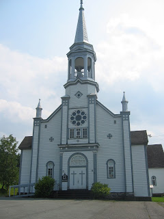
The village Catholic church, every town's got one

Let's get on with the ride!

I parked the car in Ste-Hermenengilde and rode to St-Malo and East-Hereford, and the natural beauty, rural scenery, and great roads reminded me of Vermont, except I didn't have to cross the border.

My Friend M. had said that this was her favorite spot for cycling. I had visited here a couple of decades ago, and thought it was time for another visit. It was worth it. I have found yet another beautiful spot for cycling here in Quebec.

M's directions were a bit vague, but I mapped out what looked like a good a route using Google Maps. Unfortunately this excellent trip planning device doesn't identify dirt roads. And especially, dirt roads through mountain passes!

Nothing is better than cycling through a mountain pass. It's even better when the pass is paved with asphalt! But this route was not paved, but that didn't stop me, I just had to walk one steep hill, and the rest was perfectly rideable. And the peacefulness was without comparison!

I was thinking of a ride in northeast Vermont near the border, but when I spoke to M. I decided to stay on this side of the border and explore. This was one of my more-adventurous explorations, I can tell you!

The ride started in Ste-Hermemegilde, south of Coaticook. I parked at the church and headed north on nice roads to the 9 Rang road, which took me east.

The terrain was hilly, but the road quality was good.

Todays theme: good roads, good hills, and good scenic splendour

I turned off the paved road onto a well-maintained dirt road, and was fine for cycling, and even had designated bike-road signs.


Dirt road maintained for cycling

The road maintained it's excellent quality for a while, but eventually it became single-lane and not quite as well-maintained. I did not see another soul for several miles, and I wondered, will I be eaten by wolves? Or will it be the bears that get me? Or, maybe a northern lynx? The place was that wild.

I came upon one steep hill that I had to walk, but the rest was generally rideable, even the downhills, as long as I was paying attention and staying on the solid part of the road. I had been thinking I should swap my fat 700x25 tires for 700x21, but today I was reminded why I ride the big rubber. The back one just fits inside the frame, a situation not too often found on today's anorexic race bikes.


The mountain pass road is actually marked for bicycles...

Happily I eventually came upon a sign saying I was in St-Malo municipality, and also saw a address with Chemin Eaton written on it, meaning I was on the good road, and not lost, and maybe civilization would be around the next corner, or hopefully the one after that?


A bike rest stop, sign says I'm on the good road, and what's in the tree?

Yes, did come out the other side without any carnivorous animals trailing me, hoping for a meal of tasty cyclist.

Once I was back in the populated part of the world and there was pavement under my wheels I rolled along a great road west into St-Malo, and then I would ride south to East Hereford and the US border.


St-Malo's most excellent attraction - La Tour - Altitude 590m!
St-Malo's attraction is a lookout tower they built on the highest point of land in the village, which is itself on a hill. I had my usual dep energy refill: a chocolate milk and some Reeses peanut butter cups and refilled my gatorcrapade.


St-Malo from lookout tower, the mountain pass on hazy horizon

From St-Malo it was dowhill to St-Venant de Paquette, home of a poetry trail.


Mid-ride diversion in Paquette


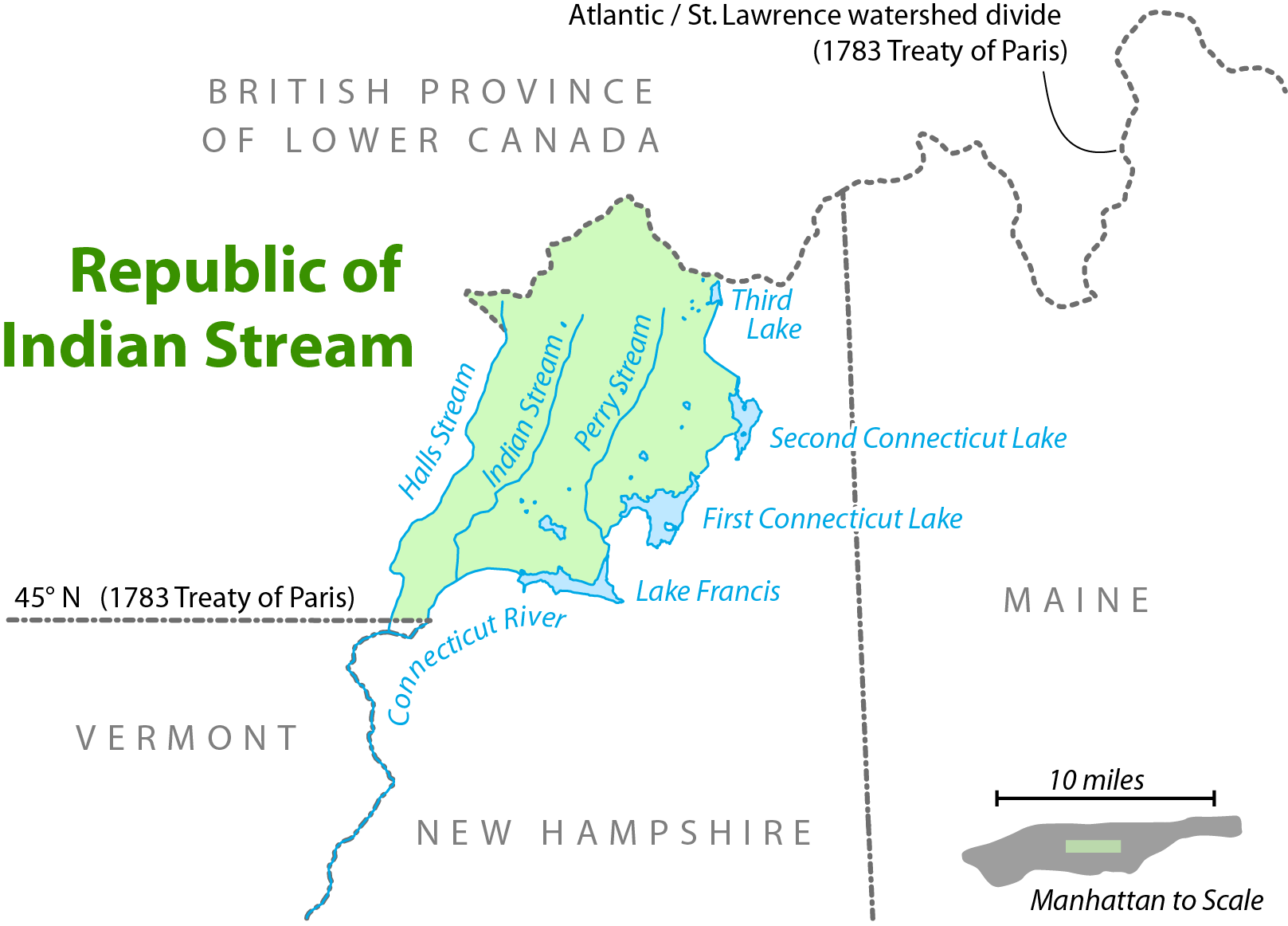
South of here I followed the Rt 253 as far as the US Border along the Hall river, the other side of the river is New Hampshire. The Hall river valley is both flat, and very scenic. It's a 6 km each way detour from the ride's turning-point in East Hereford.

Here is an interesting history item on how the US border came to be along this river. It's the story of the "Indian Stream Republic" and guess what, the land became part of the US. Quelle surprise.


The disputed land in the Indian Stream Republic


East Hereford Customs, note the thunderclouds in background, uh-oh.

Turning around at the Customs I rode back north (option is to do a loop through the US and come back north on Rt 141) , and I notice interesting, and ominous, clouds.

Uh-oh.

The weather arrived in a few minutes and it was what the weatherman describes as "Risk of Severe Thunderstorms."

Uh-oh.

So I camp out in someone's front yard, and enjoy the show, Constant lightning and thunder for the next 45 minutes.


Looks like rain, feels like rain, Sounds like thunder.

Eventually it let up and I continued home, still raining and occasional lightning. I was more than a little concerned to be riding on top of 20 pounds of metal! But the way home was where I was headed, and I was what you'd call a motivated rider!

Eventually I arrived back closer and closer to my starting point of St-Hermenegilde. Amidst the rain, black clouds, and lightning and thunder, in the distance the sky parted right above my destination, I took it as a sign that I would make it back ok, and that everything would be fine.

St-Hermenegilde in the distance, black skies with clouds parting and sun shining down looking like a sign from god. I was saved!

I got back to the car, and as I opened the door, just in time for the last piece of the weather menu to arrive.

Severe hail!

Am I glad I got to the car 30 seconds before that? Oh yeah, timing is everything, and this time my timing worked out to the second! Maybe that's too close?

Weather can be so contrary sometime.

But the hail stopped, I changed into dry clothes, and came home safe and sound.

What a day!

************
Links:
This region has another name: Les Trois Villages (click here to visit)

Thursday, August 02, 2007

Route Verte official inauguration August 10

Quebec's Route Verte 4000 km (2500 miles) provincial bike path official inauguration is on August 10 2007. Events are being held throughout Quebec.

Route Verte web site
English Route Verte news from Google news
French Route Verte news from Google news

FYI, there's more news on the french side.