 Forests and fields and farms and rivers, and geese
 A nice easy fun ride on great roads
 the leaning barn of dewittville
 some of today's thousand geese
 very old rock wall, built by hand
 The double arch design is visible
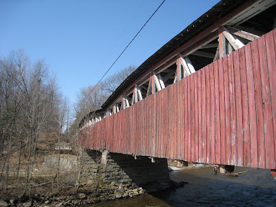
 Powerscourt's covered bridge, built in 1861
We finally got to the Powerscourt covered bridge this year. Our rides recently had taken us to the next town, but today we got to the bridge itself.
The pont Percy covered bridge is the only one in southwest quebec. It crosses the Chateauguay river just north of the US border. And there is a great sundeck on the cement foundation on the east side of the bridge. Sunday was a day that was perfect for a sundeck.
We rode there from Ormstown southwest on Gore Road, and Ridge road into Athelstan, then south to Powerscourt, where we u-turned and rode along the Chateauguay river for the ride back to Ormstown, crossing to the north side of the river at Dewittville.
Coming home we saw thousands of geese, some were coming in for a landing on the Chateauguay river.
Snacked on grease at Gregoire in Ste-Martine and ate on the picnic tables down by the river at the dam. The picnic tables down by the dam situation is a good thing.
Here is the link to the
map of the ride at Bikely. Total distance was about 50 km, mostly flat with a bit of light rolling hills.
Note: if you are using the "Monteregie road bike map" for spatial reference, you need to know that Athelstan is labeled Hichinbrooke on this map.
There are many variations to this basic route, giving a range of ride distances anywhere from 10 to 150 km. C'est vrai.


