Friday, July 30, 2010

Ste-Martine to Franklin Chateauguay Valley ride


Equipment for harvesting sunshine


Can you spot Montreal?


Amazing amount of stone fences on this ride


Covey Hill... keeps us coming back for more.

We went to Ste-Martine today and rode to Covey Hill at Franklin Centre. Then we rode downhill and with the wind all the way home. Conditions, road surface, sunshine, scenery, apples, visibility, all were perfect.

We rode from Ste-Martine to St-Chrysostome, Russeltown Flats, Franklin Centre, Ste-Antoine Abbé, and through "The Rock" and the Scotch Concession back to the Bean River and Ste-Martine, where we got some fresh corn on the cob for our supper.


The bike map is on Bikely - click here.

la Presse's vélo blog

We think the La Presse's bicycling blog "Le Québec à vélo" written by Caroline Rodgers is great. (it turns out she likes us too)

There are lots of interesting subjects, and numerous comments, for and against.

You can read it here.

Thursday, July 29, 2010

Riding bike on sidewalks

Your chances of having a collision when riding your bike on the sidewalk is 25 times greater than riding on a road or bike path.

25 times more likely to have a collision.

25 TIMES.

Pay attention here: the people the bicycle riders are running into are pedestrians. Pedestrians are people who have an absolute, complete, and total right to use the sidewalk for walking and to be safe from the danger from moving vehicles (that is a category that includes human powered vehicles like bicycles). It is called a side walk... side "walk." What part of side"walk" is for bicycles? None is the right answer.

Key Message: do not use the sidewalk like it is your own personal bike path. It isn't.

It's ok to go outside and ride your bike and have some fun, just please don't run down people on the sidewalk, And even if you think, I'm riding safely on the sidewalk, let us remind you that the pedestrians (each and every one of them) think YOU are about to HIT them with your bike.

You don't mean to scare them, but you are going a lot faster than people walking, and the sidewalk is busy, and you are riding right at them... Aieee!

Once you stop being a child (around the age you become a teenager) it is time to learn the safe way to use the road to travel on a bicycle. (Information here from the saaq, transport quebec, and velo-quebec on the subject of bicycle safety.

So let's try to have more civility, civisme, manners, etiquette, and just common sense. And get off the sidewalk.

When will Montreal have urban mountain bike trails?

When will Montreal have urban mountain bike trails? New York City has them ferchrists sake.

We would like occupants of the this 3rd millenium to enjoy the largely harmless and spirit-enhancing of off-road biking without having to travel off the island of Montreal.

marathon mountain bike ride


Riding a bike through the woods, does life get any better than this?


Nine new bridges complete the Chainon Manquant trail


We went back to East Hereford to see if the new trails Chainon Manquant and JDA were finished. Earlier this season they were walk-fests. Good news! Chainon Manquant has nine new bridges. Nine!

So we took these two trails from the Troll/Indian Stream intersection all the way to their conclusion (uphill!) to the start of Chasse-Galerie. Then we turned around, and we were happy to enjoy the fact that these two trails are downhill in the return direction.

So our ride was a combination of
  • Le Noire
  • Bobine
  • Quartz US/Quartz Cdn
  • Chainon Manquant
  • JDA
  • *turn around at end of JDA*
  • JDA
  • Chainon Manquant
  • Indian Stream
  • Panache
  • Récupe
  • Tiny bit of Quartz US
  • Bobine
  • La Sapiniere (out to the good valley view and back)
  • Le Noire

Snacks

And then the farm roads/double track north of town

  • Panorama
  • L'Express
  • Trial (counter-clockwise)
  • a bit of the Rang 9 road climb
  • L''Express
  • Panorama
Today's ride distance was around 65 km and six hours, so it was a big day. A big beautiful amazing day.


Red: single-track loop on Mont Hereford
Yellow: forest road/double track north of village

You can get lots of East hereford mountain biking information at the AllezY webpage for this destination. There is the above map and there are suggested loops based on distance/difficulty.

For an easy ride, we have noticed people, families, spouses, etc getting driven to the top of Bobine and riding back downhill to the village.

Parking for mountain bikers is behind the church. There are maps here and the paybox for the $5 they request from you in order to pay for these excellent new trails, the development of which costs money.

Sunday, July 25, 2010

Riviere Rouge Ride

Our last few rides were on flat land. Very flat land. We like flats in moderated doses, but there's fun to be found in the hills.

So up the laurentian autoroute we went. Park in St-Jovite (now rebranded "Downtown Mont-Tremblant"), at p'tit train du nord parking, then weave our way through downtown, then very shortly we are out the open countryside. In the Tremblant area, this is a very nice place to be.

This ride starts in St-Jovite, then passes through a covered bridge as the we cross over to Brebeuf, at the Riviere Rouge. This river valley is the highly scenic route for todays ride. We ride north to La Conception, and then south to Huberdeau (and sometimes Arundel: check out the steam engine at the post office).

It is sort of a T-shaped ride, and this means we pass through Brebeuf in the middle of the valley three times.

We stopped for our break in Huberdeau. Ice cream cones were substandard, but the river-side park is as good as always. Riding partner had a lot of trouble reading/understanding/obeying the no-bikes sign in this park. It doesn't say no bike-riding, it says no bikes.


This is a favorite Laurentians ride


Laurentien hills into infinity


There are many, many scenic views on this ride.


Riviere Rouge at Brebeuf


This was a dirt road before, this ride is now 100% paved


Lots of sandy beaches along the riviere Rouge


The good news is that the dirt section between Brebeuf and La Conception has had the dirt-road section paved, now the ride is 100% paved. The bad news is that the roads in general are not that great.

The best news is that the scenery is so good, you don't really mind the roads.

The ride map is on bikely here.

This ride is based on one in the Tremblant area bike map brochure. You can get all these maps (cartes in french) at velomonttremblant.com.

Thursday, July 22, 2010

our bixi stats

36 trips totaling 73 kilometres is our Bixi usage so far this year. It's not free, as is generally assumed, because you have to pay the annual membership. By the end of the season we expect our bixi per-ride cost to be around $1.

Bixi is our favorite rain bike, and we love the easy locking at the docking station for those short urban trips.

Other bikes:
mtn bike 800
road bike 1400 (has a flat right now, the jinxed rear wheel strikes again)
recumbent bike 400
city bike (blue) 2400
Rusty (the old rain bike) 5

Ste-Martine to Beauharnois Canal bike path

Some more nice'n'easy flat rides that everybody to enjoy.


Ride map. Green line is new (about to be opened) bike path link between the beauharnois canal and St-Etienne-de-Beauharnois.


Priest's home in St-Etienne-de-Beauharnois, with classy windows.


Rest stop along Beauharnois Canal bike path


Church in St-Etienne-de-Beauharnois


We have been exploring flatland between St-Martine along the Chateauguay river and the Beauharnois Canal to the north.

We found nice riding on quiet roads and the Beauharnois Canal bike path is just great with nice rest stops along the water.

If the wind is a bit strong, just remember, the ride back (with the wind) will be really great.


Eastern end of the Beauharnois Canal bike path - a cul-de-sac (dead-end) because of construction of the new Autoroute 30 toll road. (tolls!)

This western end of the bike path is about to get a new bypass and path to St-Etienne-de-Beauharnois.

The beauharnois canal bike path extends the full length of the south side of the canal, except at Beauharnois itself due to Aut. 30 construction.

Note that the quiet country road between St-Etienne-de-Beauharnois and the canal (chemin de la riviere nord) is still an excellent choice for a bike ride, the new path opens up a nice loop-ride option. This area is part of the projected new Route Verte axis along the south side of the St-Laurence river.

Sunday, July 18, 2010

Week vacation in Lac Memphremagog area


It pays to read hand-written signs


The beach at Lac Lyster (Baldwin's Mills) is the best


Quebec's smallest church


Tomifobia Nature Trail bike path is always excellent


Fields full of of lavender and picnickers at Bleu Lavendre

Sunday, July 11, 2010

Raid Jean Davignon mountain bike festival

The Raid/marathon Jean Davignon is a mountain bike festival at East Hereford in the Eastern Townships, on July 17 & 18 2010.

We like East Hereford as a mountain bike destination (a lot), and this raid is a great way to explore this away-from-civilization (no condos for miles around!) of this mountain bike paradise.

There are ride levels and distances appropriate for everyone from beginner to expert riders.

if you want to experience some of the best off-road trails in Quebec, and you want to do it with some other people and with some guided rides, this is your opportunity.

Here is the link to the Raid Jean Davignon website.

No, there is no chairlift.

Eastern Townships Trio

A trio of easy Eastern Townships bike path rides:

1) L'Estriade: Waterloo to Granby

A nice paved, serviced, away-from-roads rail-to-trail bike path. Very popular (so it can be quite busy).

2) Tomifobia Nature Trail: Ayer's Cliff to Stanstead

A nice, scenic unpaved, trail that follows the winding Tomifobia river completely away from civilization once you leave the start/end points of the trail at the villages.

3) Les Grandes Fourches: North Hatley to Lennoxville along the Massiwippi river.

A riverside unpaved bike path along the river at the bottom of the Massiwippi escarpment. Path connects to Sherbrooke at both villages, and is part of the bigger Grand Fourches Sherbrooke-region bike path network.

We like all three of these paths, when we are looking for relaxed car free bike rides.

Saturday, July 10, 2010

Montreal from an outsider's perspective

The blog "Rebuilding place in the urban space" has an interesting look at Montreal. The link is here.

For visitors from the future, the Montreal-related posts are from July 6 to July 8 2010.

Exploring Montreal's endangered heritage sites

Heritage Montreal has identified many heritage buildings and sites in Montreal that are endangered.

Since the bicycle is a great way to explore Montreal, we suggest you might find this to be an interesting theme to explore our city by visiting some of these sites, before they are gone under the bulldozer of urban redevelopment.

Click here to go to Heritage Montreal's website.

****************

In other news, Saturday's Gazette featured urban expert and McGill professor Avi Friedman's selection of some of the best architectural jewels (buildings, streets, neighbourhoods) that would also be interesting destinations for a Montreal urban bike ride. The article is called "A tour of authentic Montreal" and it follows this post's theme of finding and treasuring the jewels of Montreal's urban landscape. (This article is highly recommended.)

Read the Gazette article here. The online version even has a google map, nice job.

Wednesday, July 07, 2010

Tour des streams dans Montreal


The Mile-end stream starts in the Mount Royal Cemetery.

(If anyone knows the real name of this stream, please let us know.)


Many streams once flanked the sides of Mount Royal


A stream-themed exploration of upper Outremont

The purpose of urbanization is to remove nature from the surface and replace it with the built environment. The visual landscape of nature is replaced with a man-made facsimile. Montreal (the island) had many streams and rivers before the modern man arrived, and today very few remain anywhere near the surface.


The stream, confined (and how!) but not tamed.

The Sisters managed to seal in and fence off the stream running through their property above Cote-Ste-Catherine road. You can catch a glimpse of it on both sides of avenue Maplewood.


The Mile-End stream

What we have always called "the Mile-end stream"is one of the few above-ground streams in central Montreal.

We are not providing any detailed directions, because we think that anyone who sets out to do a bit of exploring and discovering (anyone = you) should not have too many clues.


The Peel Street stream

The renovated Peel street entrance to Mont Royal Park has a highly man-made stream that is also on the surface, and worth exploring. Especially after a rain storm when the design offers a good display of wetlands with variable hydro-periodicity. We did a photo story on it last year.


The Peel Street stream and stairs (renovations are now completed)


The Vieux Port (old Port)

The Vieux Port park has a pair of ponds that are claimed to be part of an underground stream that they put back on to the surface in the park that is the Vieux Port.


Not quite as it looked when Montreal was founded

Tuesday, July 06, 2010

Tour des lacs dans Montréal


A few lakes and ponds for your summer enjoyment.

What better way to enjoy summer than a trip to the lake? Montreal has a few lakes and ponds, and this bike ride takes you from the St-Laurence river in the old port through the Plateau (Parc Lafontaine) and Outremont, up to Beaver Lake in Mont Royal park.

Now, you can't swim in any of these lakes. But you can admire the aquatic wildlife and enjoy the peace that sitting beside water provides.

For a shorter, and still excellent ride, you can ride from parc lafontaine directly to Parc Mont Royal on Rachel street bike path.

Ride safe!
Here's the link to the map on Bikely for the Tour des lacs dans Montreal.

******************************

OK, the lakes of Montreal is a bit contrived, a meek substitute for the real thing. For the real thing, we remind you that Montreal is an island, and it has dozens of miles of excellent riverside waterfront.

Exploring our island is a great way to spend some quality time enjoying life. Our geography is one of the things that makes Montreal's quality of life so excellent. Check it out.

And a bicycle is the perfect vehicle to check it out with.

(Cycle fun's mission statement states: cycle + fun + Montreal = happiness)

Sunday, July 04, 2010

Ste-Martine and Beauharnois canal in Le Suroit region


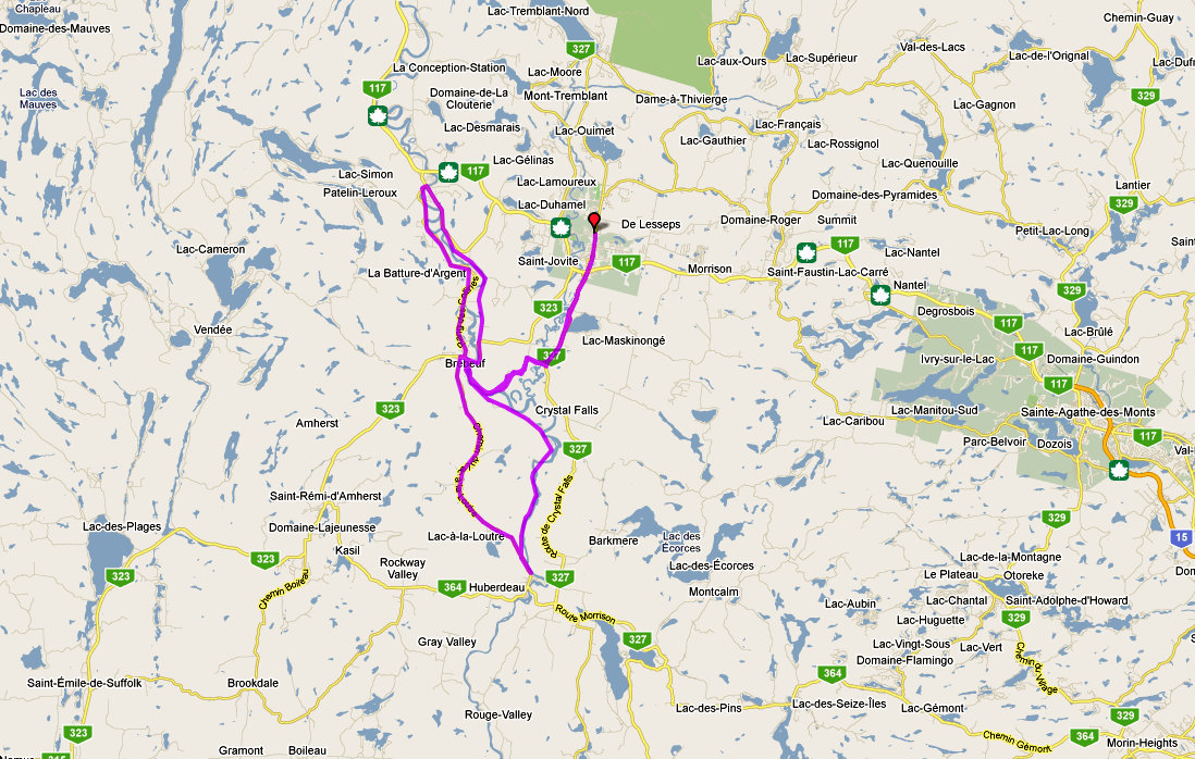
Today's bike ride, red line is side trip to Beauharnois canal and power dam

This is a flat land ride.


Hydro-Quebec's Beauharnois Dam, the St-Laurence river completely diverted for this power dam.


The bike path network in the Suroit, yellow circles are a few missing links.

Continuing our first weekend of the bike season on the recumbent bike (we wanted to give our regular bike muscles their 3000 km rest break). Riding the recumbent is great for comfort and also optimized for regular scenery-enjoying country riding.

The recumbent bike excels in flat rides, and we chose another canal for today's ride.

The route of today's ride was to ride from our regular starting point of Ste-Martine, and go north on perfectly flat land to the edge of the St-Laurence river at Beauharnois, and explore the open/closed bike path(s) around both sides of the Beauharnois canal.

Because of construction work on I rode around the beauharnois canal but not actually on it. Zones near beauharnois are closed to bikes for construction of autoroute 30. Aut 30 is the big new southern bypass of montreal island/ It is now under construction and will be a toll road. These are not popular in Quebec. Combine that with foreign ownership of the road for 35 years and we predict that Autoroute 30 will soon be a major public shitstorm. But I digress.

We had not done much riding on roads north of chateauguay river, so this turned out after much meandering) into a real nice route for the homeward bound direction from St-Louis-de-Gonzague. (this is the ride version we created on the bikely online map).

There were some major winds today (35 km/hr!), but this situation is a lot better on a low, aerodynamic and relaxed seating position recumbent bike like our Rotator Tiger. The return ride with the wind again proves to us that riding with the wind on our backs is the best thing ever.

We stopped at, but didn't go inside the beauharnois mega-power dam guided tour welcome centre. We'll be back to visit the dam when we are carrying our bike locks.

Once autoroute 30 construction/bike path blockage is finished there will be a nice loop to do from st-martine to canal and westward (this'll be 90%+ on bike path!), then home via the quiet country roads and/or chat river road.


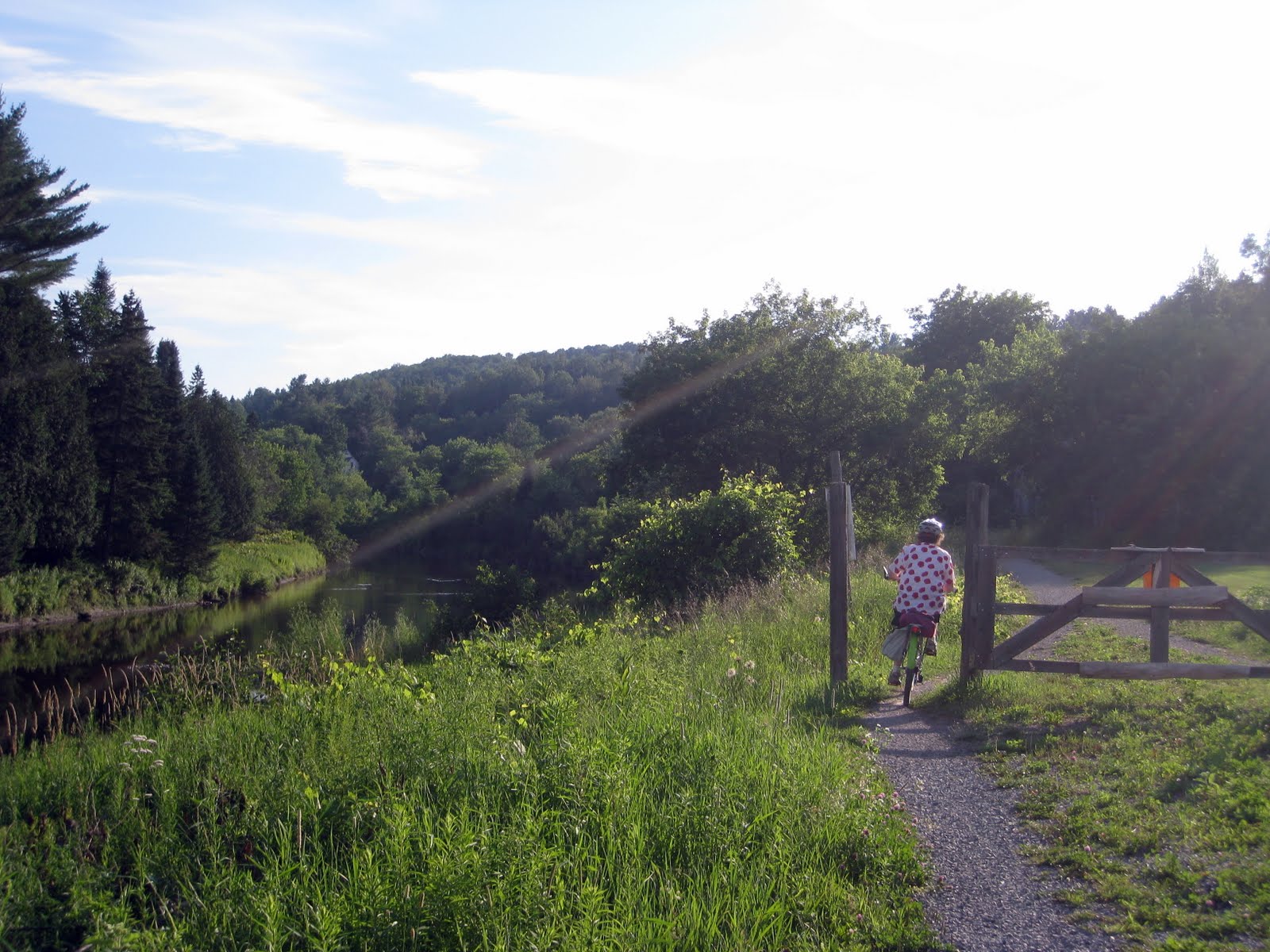
We biked underneath this ship

The road tunnels under the St-Laurence Seaway ship lock. It was a walk-the-bike sidewalk tunnel.


Birds in their maritime environment


A little bit of the Beauharnois hydroelectric power dam

This dam harnesses the St-Laurence river for 1.903 megawatts of power. That's a lot. It is one of the biggest power dams in the world. Do not put your finger on the wire.

This is Quebec's biggest dam outside of the Baie James complex in the far north. You can take a free tour. You must have I.D. if you are older than 18. There is a rooftop deck.


Montreal island and Mont-Royal from across the St-Laurence river at Beauharnois.


Hydro-Québec landscaping.


This satellite photo displays the landscaping a bit better (it's a quebec flag)


Many kite-flyers were here. A vast riverfront park is located in front of the dam.


Family of electricity pylons waving hello at us, as the electicity heads south to power America.

Quebec's peak electricity demand period is in the winter, so we have extra energy to sell to Americans in the summer. We learned today that Quebecers use 22 megawatts in summer, and 37 megawatts in winter.


Rest stop along the Ste-Martine trail part of the Parc Regional de Beauharnois-Salaberry

Recumbent bike contains version 2 bike sound system. Version 2 has the ipod+speakers on the handlebars, not in/on the rear bag. The situation is still quite improvised. It required a mesh bag, a nylon webbing strap, 6" of twist-tie, a custom ipod pocket made with clear packing tape, and a velcro-pant strap. Version 3 will be a bit more self-contained.

Bike ride map on Bikely (this is the quiet-roads/no dam version, you can add the dam)
Suroit Tourism website (anglish)
Map of bike path network in the Suroit.
Hydro-Québec Beauharnois Dam website
Autoroute 30 website

Saturday, July 03, 2010

Riding the crazy bike

Our fleet of bikes is 5 strong, 6 if you add the Bixi membership. The Bixi is replacing Rusty as our primary rain bike.

So Blue, Bertrand, Rusty, Bouncy and the Rotator are our little family. The Rotator Tiger is a recumbent, and we had not riden it yet this year, using the Bertrand road race bike as our fast road bike.

We wanted a bit more comfort for long flat rides (the Bert still rules on the hills) so we figured we should dust off the Rotator, oil the chain, and start to enjoy speed and comfort combined together.

Our ride on the Voie Maritime was the ride we chose to launch the 2010 bent season. It's an excellent little local tour (actually, not so little at 60 km) with scenery to make you remember that Montreal is an island city.

The Bent did everything it was supposed to, except it lured us to a hamburger stand in St-Catherine, because Tigers are carnivores, don'tcha know.

Friday, July 02, 2010

Voie Maritime bike path is in the middle of the St-Laurence river


The best riverside ride in Montreal, and maybe the best ride, period!

The Estacade & Voie Maritime bike path is the "wildest" bike ride in town. Leave civilization behind and ride along this thread of land surrounded by water.

We have to confess to a belief that we think that this is the best bike ride in Montreal. Ten miles of car-free riding. Amazing.

If you want to avoid city traffic, you can start the ride on Nuns Island or in Verdun. If you live on the south shore, you can start the ride in Ste-Catherine. The path goes north past the Estacade to the Excluse St-Lambert Locks, where you can access Ile Notre Dame and Parc Drapeau. Note that between the Estacade and The St-Lambert locks the roadway is dirt, not asphalt.

A link the the map on Bikely is here.

What is an Estacade? It is an ice-control bridge in english.

Why did Chemin Nordet disappear from Google maps?

One of Quebec's best cycling roads has disappeared from Google maps.

In the Laurentian hills is one of the paradise roads for cyclists, Chemin Nordet. It is located between Lac Superieur and St-Donat, and was new-built in the last decade. It is quite a road, with big hills, wide shoulders, and no condos.

For some unknown and possibly weird reason, this road disappeared from Google maps a couple of years ago.

We are beginning to believe that "You can't trust an internet map" is the truth!


Chemin Nordet in on a 2007 google map (blue dots)


Google maps in 2010 has no Chemin Nordet, not a trace!


Bing maps has the road on it.

Bring back Chemin Nordet!